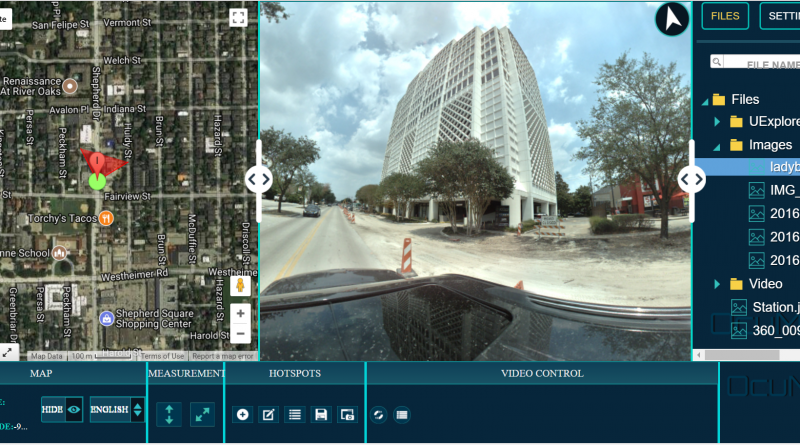
Mobile mapping can mean many things, from survey-grade LiDAR systems to a smartphone, action camera or 360 camera collecting imagery along a route. For visual documentation, the common requirement is simpler: keep the media connected to where and when it was captured.
OcuMap is designed for that documentation problem. It accepts the data you provide and organizes it around the physical locations and assets it represents. It does not create survey control or replace GIS; it helps teams work with the visual record.
GPS imagery is more useful when location stays attached
Photos and videos with location metadata can be placed on a map so a user can navigate spatially instead of searching by file name. This is useful for roads, rail, utility corridors, campuses and large sites.
- GPS-tagged photos and standard video
- 360 imagery and 360 video
- Supporting KML, KMZ, GPX and CSV data
- LAS, LAZ and E57 point clouds
- PDFs, drawings and design references
Extract visible information from the imagery
A street-level capture can also support asset documentation. Teams can review GPS-based photos or video from the office, identify visible poles, signs, structures, access points, vegetation or defects, and build an inventory list around the locations they observe.
The accuracy of any mapped information depends on the source data and capture method. OcuMap should not be presented as a substitute for survey-grade locating when precise coordinates are required.
Measure when the source supports it
Supported photos can be calibrated so users can measure lengths and areas without a point cloud. For projects with LiDAR, OcuMap’s native point-cloud viewer supports LAS, LAZ and E57 files with direct measurement. The goal is to give teams more information from the documentation they already have, while keeping the limitations of each source clear.
Compare repeat captures over time
When the same road, corridor or site is documented more than once, OcuMap can compare imagery from the same location side by side. That makes recurring inspections and condition monitoring more useful because teams can see what changed instead of simply opening two unrelated folders.
A private alternative to public street imagery workflows
Many public street-imagery platforms are designed to contribute imagery to a shared map. OcuMap takes a different approach: project documentation stays in your organization unless you intentionally publish selected information. Original files remain preserved, and Published Viewers provide a controlled way to share with clients or stakeholders.
Start documenting with OcuMap →
Practical checklist
- Decide which media type answers the project question: focused photos, 360 context, video, point clouds or a combination.
- Keep original source files and capture metadata.
- Confirm the output formats can move between systems without proprietary lock-in.
- Estimate storage and upload requirements before large collections.
- Document calibration, positioning and accuracy assumptions.
- Plan how clients and future teams will access the record.
Related resources
- Street-level mapping with a 360 GPS camera
- Public infrastructure asset inventory
- OcuMap vs. Mapillary
Common questions
Does every image need GPS?
No. GPS helps automate map placement, but documentation can also be organized manually around project locations and Features.
Does OcuMap create survey-grade coordinates?
No. Positional accuracy depends on the data supplied by the camera, GNSS receiver, survey or GIS source.
Can OcuMap work with 360 imagery and regular photos?
Yes. Both can live in the same project together with video, point clouds and documents.