Buildings
Buildings & Facilities
Existing conditions, renovations, facility management and handover, for property owners, architects and engineers.
OcuMap adapts to the way you document the physical world, from floor-based building records to map-based infrastructure and site documentation, without splitting your work across different systems.
Free plan available. No credit card required.
Existing conditions, renovations, facility management and handover, for property owners, architects and engineers.
Roads, railways, utilities, rights-of-way, campuses, industrial sites and environmental projects organized spatially around maps, routes and real-world locations.
Start from a map, floor plan, drawing, or files alone. OcuMap gives each project the context that fits the work while keeping the underlying documentation system consistent.
| Buildings & Facilities | Infrastructure & Sites | |
|---|---|---|
| You start from | A floor plan, drawing, or files alone | A map, site, route, or files alone |
| Records organize by | Building, floor, floor plan, feature, location | Map, route, feature, geographic location |
| You navigate by | Floor plans, features, media and viewers | Maps, routes, features and geolocated media |
| Typical measurements | Room widths, ceiling heights, clear areas | Lane and shoulder widths, clearances, surface areas |
| Typical handover | A published viewer for the owner or the next trade | A published viewer for an agency, owner, consultant, or contractor |
| Starting workspace | Floor Plan / Drawing / Files Only | Map / Site / Files Only |
Working on both? A campus can contain map-based site documentation alongside building and floor-based records. The starting context sets where you begin, not where you finish; additional spatial and file contexts can be added as the project evolves.
Whichever kind of place you document, the platform works the same way.
Give the documentation a structured home and pin every record to the place it describes.
In a building: level two, east wing, mechanical gallery.
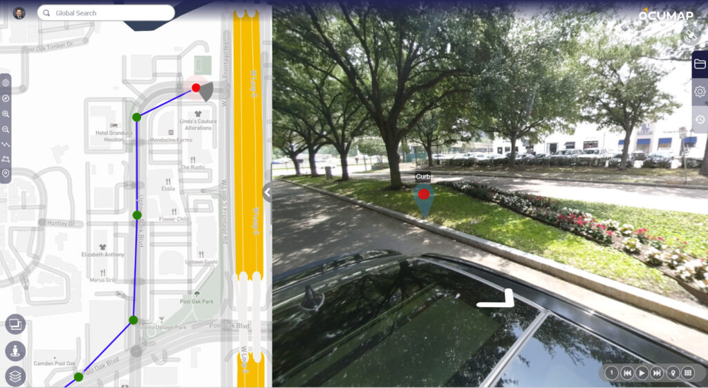
Along a corridor: Post Oak Boulevard, northbound, MP 14+230.
Move through photos, 360° imagery, video, point clouds, maps and floor plans in connected viewers. Compare documentation side by side across dates and measure directly within calibrated photos and point clouds.
In a building: step from the plan into the room.
Along a corridor: travel the route point by point.
Create curated Published Viewers for clients and stakeholders without exposing the working environment. Use password protection, comments, download controls and controlled guest participation where appropriate.
In a building: the owner and the next trade.
Along a corridor: the agency, a contractor, or the public.
Preserve original uploaded files alongside optimized viewing copies, maintain historical documentation, and keep a lasting record of how the project changes over time.
In a building: before and after a renovation.
Along a corridor: inspection to inspection, season over season.
OcuMap supports visual documentation workflows across public agencies, engineering teams, facilities, transportation and infrastructure projects.
Street-level documentation used as a planning reference and as a baseline for future assessments.
360° site documentation published for review across a statewide programme.
Visual documentation organized around real-world assets and project locations.
OcuMap is hardware agnostic. Use the cameras, scanners, mobile devices, drones and capture workflows that fit your project, then organize the resulting visual documentation in one connected workspace.
Photos (JPG, PNG), 360° imagery, standard video (MP4), and native point clouds (LAS, LAZ, E57).
DWG, RVT, FBX, OBJ and GLB, opened through Autodesk-powered viewing alongside project documentation.
PDFs, maps, GPS data, KML, KMZ, GPX, GeoJSON, CSV and related project documents.
Measure directly within calibrated photos and point clouds. In-photo measurement works without a point cloud: calibrate the image, then measure lengths and areas. Native point-cloud measurement is also supported for spatial verification and review.
OcuMap preserves original uploaded files alongside optimized viewing copies. Use the capture equipment that fits your work, keep your source documentation, and avoid unnecessary proprietary lock-in.
Use cameras, scanners, mobile devices and drones that fit the project.
Keep source uploads alongside optimized copies used for browser viewing.
Maintain visual documentation and historical context beyond the project that created it.
Yes. Both live in the same organization and the same plan. You choose a starting workspace when you create each project, so a building project and a corridor project sit side by side in one account.
Create it as a Map / Site / Files Only project and add floor plans to it as the buildings come into scope. The starting workspace sets where you begin, not where you finish; map, floor plan and file organization can all be added to a project later.
No. OcuMap is hardware agnostic. Use the cameras, laser scanners, mobile devices, drones and capture workflows that fit your project, then bring the resulting documentation into OcuMap.
Yes. OcuMap includes a permanent Free plan so you can start with your own documentation without a credit card. See Pricing for current storage, team and publishing limits.
Yes. Your original uploaded files remain yours and can be downloaded in their original format. OcuMap is designed around data ownership and long-term preservation rather than proprietary lock-in.
Bring your own building, facility, site or infrastructure documentation into OcuMap and organize it in the context that fits the work.