Here is a Quick Guide to selecting the right drone for your aerial mapping projects
How often have we wanted to get a bird’s eye view with location intelligence from a certain height? Drones give you the chance to view everything from an aerial point of view. In simple terms, a drone is an Unmanned Aerial Vehicle (UAV) or system. It is being incorporated into various industries that make it absolutely indispensable. One of the most important applications is used in aerial mapping and imaging of infrastructure, but that is not all.
In fact, drones are grabbing the eyeballs so fast that a popular online shopping portal plans to use drones as a part of its delivery process. However, drones are not only attracting bigger industries but even hobbyists and enthusiasts are all-ready to shed a few dollars for drones.
The important question here is – how do you select the right drone for your mapping needs? if you are looking to outsource this service, how can a commercial drone service be incorporated into your business in the most efficient way?
Before we get into the details of how drones can be suited to specific tasks and industries, let us first understand the parameters that we need to focus on for selecting the right robot.
Selecting The Right Drone
1. Type of aircraft
This is the most important choice one has to make while selecting the best drones. There are many different classifications of drones. But if you have to choose an unmanned vehicle for a particular industry, it comes down to choosing between multi-rotor, fixed wing, and a single rotor.
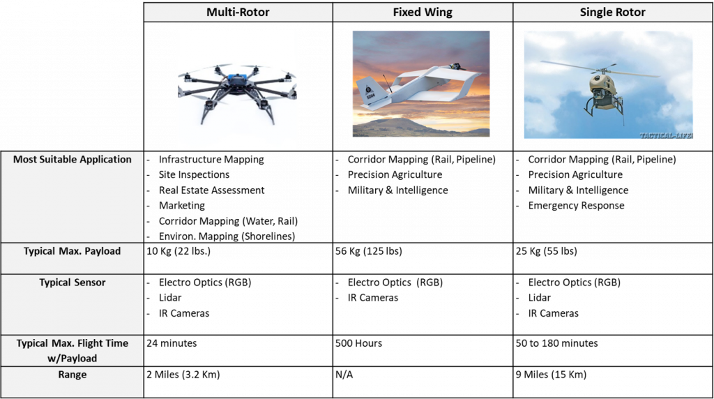
A multi-rotor has a number of propellers attached. For instance, you can use tricopters, quadcopters, hexacopters and the likes. While the first two types are mainly small drones, the hexacopter is of a larger size. These are differentiated based on their range of travel in the air, payload capacity, and flight time. Besides, several applications and equipment like cameras, GPS, stabilizers can be added to these drones to boost their utility. These multi-rotor drones are more useful for infrastructure mapping and real estate assessments, which make use of aerial imaging, and aerial mapping applications.
Coming to single rotor UAV, these are known to be more efficient and productive than multi-rotors. They are a perfect option for you when you are trying to use large sensors. For instance, a Light Detection and Ranging (LIDAR) sensor would work best on a single rotor drone.
Fixed wing drones are said to be the most efficient when it comes to covering many miles per flight in a short period. This is why this kind of a drone has found a lot of importance in military and intelligence. It can take up a payload of 56 kg or 125 pounds, which prove to be quite useful for using big IR cameras. It also has the highest flight time touching 500 hours on an average.

Which Gimbal is right for my project?
2- Payload
The maximum payload supported by the drone, determines the kind of sensors you can attach with the device, and the possible accessories that can be used. In this regard, a multirotor drone will give you pretty average payloads. This means, you will be able to attach a 200 gram 360 camera, and the device will work well with it.
On the other hand, if you are opting for LIDAR laser scanning, or 3D mapping, your best bet would be a single-rotor drone. One of the reasons why a single rotor type of a drone is really popular is because of its heavy payload carrying capacity.
How Much data can I collect in one flight?
3. Time of Flight (TOF)
It is preferable to have a high payload carrying capacity in order to make good use of the drone. However, it must also be noted here that a heavier payload can have a stronger impact on the battery life and the flight time of these aerial vehicles. You might be able to carry heavier gimbals, but the device would not work for too long before it needs refueling or recharging.
The flight time dictates the duration for which the drone can be in the air till it is time to recharge its battery. A multi-rotor drone might be swift, but it comes with a shortened flight time. Thus, it is more suitable for smaller scale aerial imaging and mapping. On the other hand, the single rotor motor can work up to 3 hours on a single charge of battery.
A fixed motor drone is a winner here. It can achieve flight times exceeding 8 hours and that makes it useful for long corridor mapping, and military applications.
How far can drones fly and are they legal?
4. Range
The range of an unmanned aerial vehicle is the next important factor to look into. This is a rather important consideration. Why is it so? In order to fly the drone, you have to use a remote with a sensor and control it from ground level. Now, the higher the range, the farther your device will be able to fly without losing signal from your remote control. Thus, using a drone with a higher control range will only act to your advantage. It is important to note that in the U.S, FAA guidelines permit drone operators to fly only within 400 feet altitude, within line of sight. Special permits could be filed with FAA for independent evaluation.
When we are working with drones, specific to a particular industry, this feature will help you determine how far the UAV can be go. For instance, the multirotor is well suited for short distance/low altitude flights, and thus, it is the best option for pipeline inspection, power line and utility inspections.
What do you do with the drone data?
5. Drone Data Management
This is the most crucial question to ask. What do I need to do with the data? drones can deliver 2D and 3D data dependent on the project requirements. 2D data can be geo images, geo video, or an orthomosaic, while 3D data can be a digital surface model, digital terrain model, or pointcloud. There are different software packages available for each deliverable, and the process for collecting the data differs depending on the required outcome. Let us now consider two examples of what to consider when you are planning an aerial mapping project for railroads and emergency response.
Example: Aerial Mapping for Railroads
Steps below list planning consideration for corridor mapping using drones or UAVs
- Define the area of interest. In this case, it could be railway divisions, and sub-division. Look into no-fly zones to make sure you can get a permit to fly the area.
- List the assets that need to be documented. This could be structures, crossings, right of way, etc.
- Define the data format needed from the flight (Video, 360 Video, Images, Geo-referenced, Pointcloud, etc.) This step should also include turnaround time, data delivery methods, etc.
- Define the stakeholders who may benefit from this data internally, and externally (contractors). This would help maximize the value of the project and get other groups within the company to share the cost.
- Do a pilot project. While drones are becoming widely accepted in aerial mapping, the technology is still new and evolving. It is recommended that each company does a pilot project to understand the limitations, and value before planning a large scale effort.
- Document lessons learned and gather feedback from stakeholders on how the process could be improved.
Example: Aerial Mapping for Emergency Response
While planning for emergencies is beyond the purpose of this example, steps below list how an entity can be prepared to work with drones during an emergency response situation.
- Based on the identified risks and response priorities in the risk register, identify areas that need immediate intelligence. This will help decision makers rapidly assess the situation.
- Calculate response time of the drone to your site location. Conduct drills and exercises by deploying drones to respond.
- Have a clear understanding of the needed data that a UAV must deliver. Look into live video feed.
- Make sure the data is geo-referenced with a map, showing the exact location of the drone
- Decide on how many units might be needed based on the worst case scenario, and include it in the emergency response plan
- Exercise getting fast waiver to fly in a restricted airspace.
At the end of the day, drones are tools to help streamline your mapping needs
Weather you chose a single rotor, multi-rotor, or fixed wing, a drone is a tool to help you increase your efficiency and gather better information on your site of interest. Drones are now a vital tool in mapping and imaging infrastructure, site inspections, real estate management, corridor and environmental mapping, precision agriculture, and emergency response! Curious? Talk with Reality IMT, and discover other amazing ways a drone can be put to use in your aerial mapping efforts.
