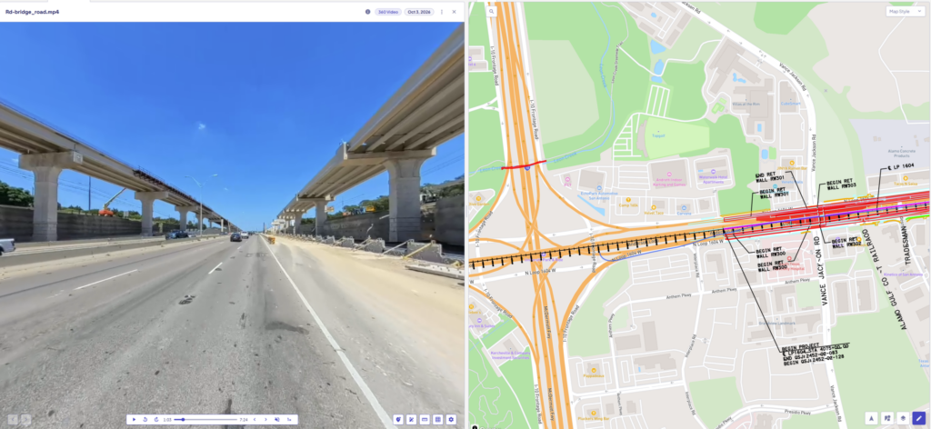
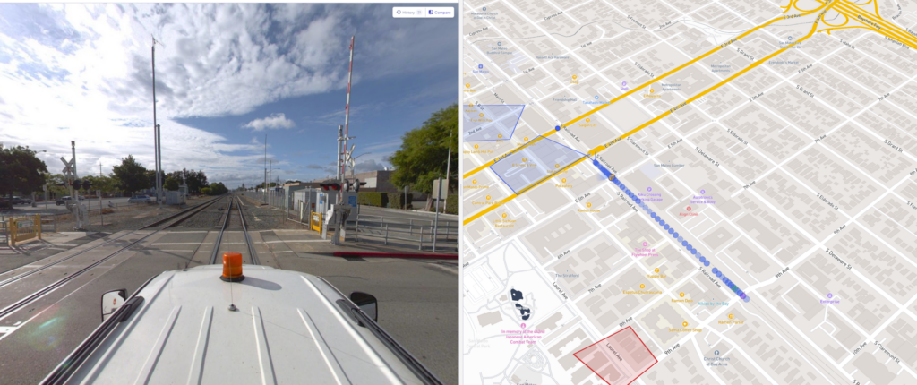
Street Mapping
[vc_row full_width=”stretch_row” disable_element=”yes” el_id=”section-1″][vc_column][ocumap_hero_section section_style=”v2″ breadcrumps=”true” css=”.vc_custom_1687368039405{background-image: url(https://ocumap.sytes.net/wp-content/uploads/2023/01/Group-105.jpg?id=2159) !important;background-position: center !important;background-repeat: no-repeat !important;background-size: cover !important;}” sentences_color=”#ffffff” section_img=”2597″][/vc_column][/vc_row][vc_row el_id=”section-2″][vc_column][vc_column_text css_animation=”fadeInUp”]
Three simple steps to mapping street assets
[/vc_column_text][vc_empty_space height=”3rem” mobile_height=”2rem”][vc_row_inner content_placement=”middle”][vc_column_inner offset=”vc_col-lg-5 vc_col-md-5″][vc_single_image image=”2903″ img_size=”full” alignment=”center” css_animation=”fadeInLeft”][/vc_column_inner][vc_column_inner offset=”vc_col-lg-7 vc_col-md-7″][vc_custom_heading text=”1. Use any GPS camera to collect images/videos” font_container=”tag:h3|text_align:left” use_theme_fonts=”yes” css_animation=”fadeInRight” font_weight=”regular”][vc_column_text css_animation=”fadeInRight” el_class=”ul-style”]Images, videos and GPS data can be collected using smartphones, drones, 360 cameras, DSLRs and action cams. OcuMap uses standard jpeg format with EXIF and standard mp4 format with GPS embedded in the video file.[/vc_column_text][/vc_column_inner][/vc_row_inner][vc_row_inner rtl_reverse=”yes” content_placement=”middle”][vc_column_inner][vc_empty_space height=”9rem” mobile_height=”2rem” el_class=”arrow-1″][/vc_column_inner][vc_column_inner offset=”vc_col-lg-5 vc_col-md-5″][vc_single_image image=”2835″ img_size=”full” alignment=”center” css_animation=”fadeInRight”][/vc_column_inner][vc_column_inner offset=”vc_col-lg-7 vc_col-md-7″][vc_custom_heading text=”2. Drag & drop images/videos, see them on the map” font_container=”tag:h3|text_align:left” use_theme_fonts=”yes” css_animation=”fadeInLeft” font_weight=”regular”][vc_column_text css_animation=”fadeInLeft”]OcuMap allows you to see where your data is located, instantaneously. Navigate from one image to another. Pan around in 360 and zoom in and zoom out to see the big picture. Plus, get the GPS coordinates of each photo using EXIF data.[/vc_column_text][/vc_column_inner][/vc_row_inner][vc_row_inner content_placement=”middle” el_class=”row_3″][vc_column_inner][vc_empty_space height=”9rem” mobile_height=”2rem” el_class=”arrow-2″][/vc_column_inner][vc_column_inner offset=”vc_col-lg-5 vc_col-md-5″][vc_single_image image=”2662″ img_size=”full” alignment=”center” css_animation=”fadeInLeft”][/vc_column_inner][vc_column_inner offset=”vc_col-lg-7 vc_col-md-7″][vc_custom_heading text=”3. Geotag street features directly from photos/videos” font_container=”tag:h3|text_align:left” use_theme_fonts=”yes” css_animation=”fadeInRight” font_weight=”regular”][vc_column_text css_animation=”fadeInRight”]Tag features inside photos with a single click. Grab the GPS coordinates at the tagged location and pint it to the map instantly. Create your list of features once and tag them along thousands of miles with custom fields.[/vc_column_text][/vc_column_inner][/vc_row_inner][/vc_column][/vc_row][vc_row][vc_column][vc_empty_space height=”4.167vw” max_height=”80px”][/vc_column][/vc_row][vc_row el_id=”section-3″ css=”.vc_custom_1693232370433{border: 1px solid #ffaa1e !important;}”][vc_column css=”.vc_custom_1693232342680{background-color: #ffaa1e !important;}”][vc_custom_heading text=”Interested in this feature?” font_container=”tag:h2|font_size:1.6rem|text_align:left|color:%23ffffff” use_theme_fonts=”yes” font_weight=”regular”][vc_btn title=”Try it now” style=”custom” custom_background=”#ffffff” custom_text=”#ffaa1e” align=”center” css=”” link=”url:https%3A%2F%2Fapp.ocumap.com%2F%23%2Fregister%3Ftype%3Dtrial|title:Try%20Now|target:_blank”][/vc_column][vc_column][vc_custom_heading text=”Need help collecting imagery as a service? reach out to us.” font_container=”tag:h2|font_size:1.6rem|text_align:left” use_theme_fonts=”yes” font_weight=”regular”][vc_btn title=”Contact us” style=”outline-custom” outline_custom_color=”#ffaa1e” outline_custom_hover_background=”#ffaa1e” outline_custom_hover_text=”#ffffff” align=”center” link=”url:https%3A%2F%2Focumap.com%2Fcontact-us%2F|title:Contact%20us”][/vc_column][/vc_row][vc_row][vc_column][vc_empty_space height=”4.948vw” max_height=”95px”][vc_custom_heading text=”Utilized by:” font_container=”tag:h2|font_size:2rem|text_align:left” use_theme_fonts=”yes” font_weight=”medium”][/vc_column][/vc_row][vc_row equal_height=”yes” el_id=”section-4″][vc_column width=”1/3″ css=”.vc_custom_1693237386576{background-color: #f5f5f5 !important;}” offset=”vc_col-lg-1/5 vc_col-md-1/5 vc_col-xs-12″][vc_custom_heading text=”Counties & Cities” font_container=”tag:h2|font_size:1.667rem|text_align:left” use_theme_fonts=”yes” font_weight=”bold”][vc_separator color=”custom” accent_color=”#b7b7b7″][vc_column_text]Perform Land, property and pavement condition assessment[/vc_column_text][/vc_column][vc_column width=”1/3″ css=”.vc_custom_1693237381412{background-color: #f5f5f5 !important;}” offset=”vc_col-lg-1/5 vc_col-md-1/5 vc_col-xs-12″][vc_custom_heading text=”Public Works” font_container=”tag:h2|font_size:1.667rem|text_align:left” use_theme_fonts=”yes” font_weight=”bold”][vc_separator color=”custom” accent_color=”#b7b7b7″][vc_column_text]Infrastructure quality assessment, documentation and maintenance support.[/vc_column_text][/vc_column][vc_column width=”1/3″ css=”.vc_custom_1693237395246{background-color: #f5f5f5 !important;}” offset=”vc_col-lg-1/5 vc_col-md-1/5 vc_col-xs-12″][vc_custom_heading text=”Public Safety” font_container=”tag:h2|font_size:1.667rem|text_align:left” use_theme_fonts=”yes” font_weight=”bold”][vc_separator color=”custom” accent_color=”#b7b7b7″][vc_column_text]Emergency response and planning for public safety and law enforcement[/vc_column_text][/vc_column][vc_column width=”1/3″ css=”.vc_custom_1693237408509{background-color: #f5f5f5 !important;}” offset=”vc_col-lg-1/5 vc_col-md-1/5 vc_col-xs-12″][vc_custom_heading text=”Transportation” font_container=”tag:h2|font_size:1.667rem|text_align:left” use_theme_fonts=”yes” font_weight=”bold”][vc_separator color=”custom” accent_color=”#b7b7b7″][vc_column_text]Review and assessment of signage, signals and wayfinding guides[/vc_column_text][/vc_column][vc_column width=”1/3″ css=”.vc_custom_1693237417028{background-color: #f5f5f5 !important;}” offset=”vc_col-lg-1/5 vc_col-md-1/5 vc_col-xs-12″][vc_custom_heading text=”Urban Planning” font_container=”tag:h2|font_size:1.667rem|text_align:left” use_theme_fonts=”yes” font_weight=”bold”][vc_separator color=”custom” accent_color=”#b7b7b7″][vc_column_text]Pedestrian walkway infrastructure assessment and ADA compliance[/vc_column_text][/vc_column][/vc_row][vc_row full_width=”stretch_row_content_no_spaces”][vc_column][vc_empty_space height=”7.708vw” max_height=”148px”][/vc_column][/vc_row][vc_section el_id=”faq-wrapper”][vc_row full_width=”stretch_row” el_id=”faq-section” css=”.vc_custom_1673637528315{background-color: #f5f5f5 !important;}”][vc_column][vc_empty_space height=”20px”][vc_custom_heading text=”Frequently Asked Questions” font_container=”tag:h2|font_size:3rem|text_align:left” use_theme_fonts=”yes” font_weight=”bold” mobile_fontsize=”2rem”][vc_empty_space height=”35px” mobile_height=”25px”][vc_tta_accordion style=”modern” shape=”square” active_section=”1″ no_fill=”true” collapsible_all=”true”][vc_tta_section title=”What is OcuMap?” tab_id=”1673293626468-70c16865-022e”][vc_column_text]
OcuMap is an innovative mapping platform that helps you combine Reality Capture (images), GIS (location) and BIM (3D) to better manage your projects, optimize operations, and make more informed decisions.
[/vc_column_text][/vc_tta_section][vc_tta_section title=”Who uses OcuMap?” tab_id=”1673293743333-4073e133-68ce”][vc_column_text css_animation=”bounceIn”]
OcuMap is used by:
Project Managers who need visual documentation of their infrastructure projects.
GIS experts who need to extract features directly from imagery.
City Planners who need better understanding of the streetscape
Right of Way Engineers to plan maintenance.
Civil Engineers to Assess Roadway Damages
Environmental Scientist for NEBA
OcuMap can be used in many different industries, whether in engineering and construction, petroleum, roads, transportation, or local government
[/vc_column_text][/vc_tta_section][vc_tta_section title=”Which GPS camera works best with OcuMap?” tab_id=”1673293784719-34e5278f-ce17″][vc_column_text]
You can use any GPS-enabled camera. OcuMap supports .mp4 video files and .jpeg image files. If you are recording video with GPS, make sure you can export a GPS data file out of the camera in simple text format (txt, csv, xml) or GPX.
[/vc_column_text][/vc_tta_section][/vc_tta_accordion][vc_empty_space height=”35″][/vc_column][/vc_row][/vc_section][vc_row full_width=”stretch_row” css=”.vc_custom_1667828808086{background-color: #ffffff !important;}” el_id=”section-10″][vc_column css=”.vc_custom_1673378307051{padding-top: 0px !important;}”][vc_empty_space height=”3vw”][/vc_column][vc_column css_animation=”none” offset=”vc_col-lg-6 vc_col-md-6″ el_class=”txt-column”][vc_custom_heading text=”Create an OcuMap Account” font_container=”tag:h2|text_align:left|line_height:1.2″ use_theme_fonts=”yes” css_animation=”none”][vc_empty_space height=”1vw” mobile_height=”3vw”][vc_btn title=”TRY OCUMAP NOW” align=”left” link=”url:https%3A%2F%2Fapp.ocumap.com%2F%23%2Fregister%3Ftype%3Dtrial|target:_blank”][vc_custom_heading text=”Start visually mapping your data now with a 14-day free trial.” font_container=”tag:h3|text_align:left|line_height:1.2″ use_theme_fonts=”yes” css_animation=”none”][vc_empty_space height=”1.5vw” mobile_height=”3vw”][vc_column_text css_animation=”none”]
“The video map provided us with intelligent visual information to be used as a reference for planning, and as a baseline for comparison with future assessments.”
[/vc_column_text][vc_single_image image=”1722″ img_size=”full” alignment=”center” css_animation=”none”][vc_column_text css_animation=”none” css=”.vc_custom_1673377608323{margin-top: 35px !important;background-image: url(https://ocumap.sytes.net/wp-content/uploads/2022/11/houston-public-works.png?id=1763) !important;}” el_class=”credits”]The City of Houston
Rod P. Deputy Director[/vc_column_text][/vc_column][vc_column offset=”vc_col-lg-6 vc_col-md-6″][vc_column_text css_animation=”none”][ls_content_block id=”1783″ para=”full”][/vc_column_text][/vc_column][vc_column css=”.vc_custom_1667580280676{padding-top: 0px !important;}”][vc_empty_space height=”3vw”][/vc_column][/vc_row]