Poles & overhead equipment
Preserve dated visual records of poles, attachments, overhead equipment, surrounding conditions, and available measurements at known locations.
Organize photos, 360° imagery, point clouds, maps, drawings, and field records along utility corridors and sites. Keep every visual record connected to its location and capture date so teams can review conditions without searching through disconnected files.
Free plan available. No credit card required.
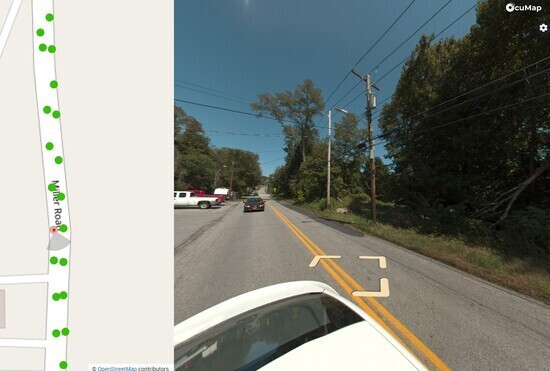
Keep visible conditions, field context, and supporting records connected to the locations they describe across the life of the network.
Preserve dated visual records of poles, attachments, overhead equipment, surrounding conditions, and available measurements at known locations.
Preserve visual conditions, surrounding context, access constraints, and available measurements at known utility locations.
Document visible conditions, access constraints, vegetation, structures, and potential encroachments along known rights-of-way and easements.
Keep visual records of meters, service points, access conditions, and surrounding site context connected to their mapped locations.
Capture trees, structures, vegetation, and other visible conditions along the corridor so teams can review how conditions change over time.
Compare documentation from the same location side by side across capture dates to understand visible changes, repairs, and recurring conditions.
Having a dated visual record at every pole and vault location gives us confidence in our asset condition and makes emergency response decisions faster.— Jane R., Asset Management, NYSEG (New York State Electric & Gas)
OcuMap is hardware agnostic. Use the cameras, scanners, mobile devices, drones and capture workflows that fit your project, then organize the resulting visual documentation in one connected workspace.
Capture with the cameras, scanners, mobile devices, drones, or field workflows appropriate for the project. OcuMap does not require proprietary capture hardware.
Upload GPS-tagged media for spatial placement, or organize documentation manually around maps, locations, and Features.
Review photos, 360° imagery, and native point clouds. Calibrate supported photos to measure lengths and areas, and measure directly within point-cloud data.
Create a curated Published Viewer for contractors, agencies, operations teams, or other stakeholders without exposing the internal workspace.
No. OcuMap does not locate underground utilities or determine their position. It displays and organizes the information you provide. If your existing utility data is available in supported formats such as KML, KMZ, GPX, or CSV, OcuMap can display that information spatially on the map alongside photos, 360 imagery, videos, point clouds, and other project documentation.
Yes. OcuMap is designed to turn GPS-based field documentation into an organized visual record. GPS-tagged photos and videos can be displayed at their capture locations, helping teams document poles, vaults, service points, equipment, right-of-way conditions, and other visible assets. You can build and maintain an asset inventory from this documentation, keep records connected to their locations, and compare historical imagery side by side to understand what changed over time
You decide. A published viewer opens in a browser and never exposes the workspace behind it. Operators, contractors, right-of-way groups and emergency responders can each see only what you choose to publish.
Yes. Re-capture the corridor on a regular schedule and keep each record tied to its location and date. OcuMap can compare documentation from the same location side by side so teams can understand how visible conditions changed across inspections, maintenance cycles, or repairs.
Start free with your own documentation, or explore how OcuMap supports infrastructure and site workflows.